Revitalization and protection of ecological systems disturbed by natural disasters
Partners
- Technical university in Zvolen,
- Institute of Geoinformatics and Cartography, TU Wien,
- The conference was organized with the financial support of the Austrian Information Center for Scientific Cooperation, SAIA n.o. within the project TU-2: bilateral cooperation between TU Zvolen and TU Wien.

Program
9:00 prof. Ing. Ján Tuček, CSc., Welcome address
Section 1
- 9:05 prof. Ján Tuček, TU Zvolen, Influence of the geographical and forestry parameters of forest stand to the forest fire occurrence
- 9:20 Peter Fleischer, Milan Koreň, Research Station of TANAP, ŠL TANAP, Tatranská Lomnica, Natural disasters in Tatras region
- 9:35 prof. Anton Osvald, Andrea Majlingová, TU Zvolen, Response of selected coniferous tree species to fire event
- 9:50 Marián Lopuch, HaZZ, Poprad, Forest fire – tactical methods of liquidation
- 10:05 Peter Weisenpache, Slovak Academy of Science, Bratislava, Forest Fire Computer Simulation using FARSITE Simulator
Coffee break 10:30
Section 2
- 10:50 Piotr Wężyk, Grzegorz Zajączkowski, Mateusz Sztreme, Poland, Geoinformation technologies applications in the mapping of widstorm area in Pisz primeval forest (north East Poland)
- 11:05 Gerhard Navratil, TU Vienna, Data quality for spatial planning – an ontological view
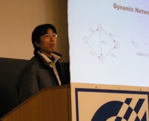
- 11:20 Takeshi Shirabe, TU Vienna, Shortest path search from a physical perspective
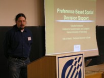
- 11:35 Claudia Achatschit, TU Vienna, Preference based spatial decision support
Lunch 12:00
Section 3
- 13:30 YMS, a.s., Trnava, Mobile data collection via GIS
- 13:45 Intergraph ČR, s.r.o., Praha, World of map services
- 14:00 ATopo, s.r.o., Banská Bystrica, Mobile mapping and data collection
- 14:15 Ornth, s.r.o., Banská Bystrica, The use of GPS in large forest fires extinguishment
Coffee break 14:30
Section 4
- 15:00 Marek Fabrika, TU Zvolen, Decision support for forest ecosystem management by model SIBYLA and GIS
- 15:15 doc. Jaroslav Hofierka, University of Prešov, Modelling overland water flow and erosion processes using open-source GIS
- 15:30 Miroslav Lukáč, Water Research Institute, Bratislava, The use of numerical modelling and GIS in the project of slovak-austrian Morava river reach restoration
- 15:45 M. Koreň, J. Tuček, V. Papaj, TU Zvolen, Regional model of forest ecosystems
Sponsors